
Business Details
28 Years
experience
Trusted Surveying Services in Chesterfield
Established in 1998, we are a dedicated team of professional surveyors based in the heart of the Peak District. Our expertise spans topographic land surveys, quarry volumetrics, 3D modelling, and aerial photography using state-of-the-art Leica equipment and CAA-licensed drones. With nationwide coverage from our Chesterfield location near the M1 motorway, we serve architects, construction firms, quarry operators, and civil engineers. Our commitment to precision is matched by our dedication to client relationships, ensuring tailored solutions for projects ranging from small residential developments to large-scale industrial sites.We maintain rigorous safety standards through Avetta accreditation and Safety Pass Alliance training, while our drone operations comply with CAA regulations including public liability insurance up to 1 million. Our 25 years of experience combine with continuous technological innovation to deliver surveys that exceed expectations in accuracy, efficiency, and value for money.
Services
Topographic Surveys
Drone Services
Aerial Photography
3D Modelling
Volumetric Calculations
Setting Out Surveys
Visual Impact Assessments
Geotechnical Appraisals
Underground Mine Mapping
Orthomosaic Imaging
Details
- Year established: 1998
Highlights and features
- Established in 1998 with 25 years' experience in professional surveying
- CAA-licensed drone operators with public liability insurance up to 1 million
- Utilise state-of-the-art Leica surveying equipment and 3D modelling software
- Tailored services for clients from small architectural firms to major quarry operators
- Avetta-accredited health & safety compliance and mineral industry safety training
Associations and certifications
- Avetta
- Civil Aviation Authority
- Drone Pilot Academy
- Safety Pass Alliance
What people say
Fast service
Accurate data
Competitive pricing
Professional team
Meeting deadlines
Services
Topographic Surveys
We conduct detailed topographic surveys using advanced Leica equipment to create accurate digital terrain models. Our surveys form essential baselines for architectural designs, construction projects, and land development plans. Clients benefit from precise elevation data and feature mapping that meets strict industry standards.
Drone Services
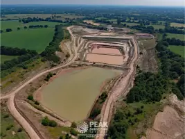
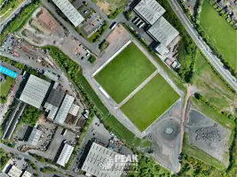
CAA-licensed drone operations provide high-resolution aerial photography and videography for site documentation. Our orthomosaic imaging combines hundreds of georeferenced photos to create detailed site maps. This technology enables efficient monitoring of large areas while maintaining compliance with aviation safety regulations.
3D Modelling
We transform survey data into comprehensive 3D models for project visualisation and planning. Our models support virtual walkthroughs, construction simulations, and landscape impact assessments. This service helps clients understand spatial relationships and potential development challenges before implementation.
Volumetric Calculations
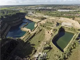
Specialist quarry and stockpile volumetric calculations ensure accurate resource management. Using reflectorless laser scanning and drone-captured data, we provide precise volume measurements for mining, waste management, and construction projects. This service supports operational planning and regulatory reporting requirements.
Visual Impact Assessments
Our ZVI (Zone of Visual Impact) assessments evaluate development effects on landscapes using geospatial data. This service identifies potential visual conflicts early in planning stages, enabling effective mitigation strategies. Clients receive detailed reports with line-of-sight analysis and tonal impact maps.
People
Jim Mundy
Architect
Architect with 20+ years' experience specifying survey requirements for building design projects. Regularly collaborates with Peak Surveying for accurate topographic data to inform architectural plans.
Mike Bailey
Project Manager
Construction project manager with Merriman Ltd, coordinating surveying requirements for infrastructure developments. Has managed 10+ years of collaborative projects with Peak Surveying's team.
Mick Smith
Group Geologist
Geologist overseeing quarry operations requiring precise volumetric calculations. Relies on Peak Surveying's data for operational planning and regulatory compliance across multiple mineral extraction sites.
Darren Ridout
Head of Land Regeneration
Land regeneration specialist utilising survey data for four years to inform sustainable development projects. Coordinates complex site assessments requiring integrated 3D modelling and topographic information.
Shaun Engert
Quarry Manager
Quarry operations manager implementing drone-based monitoring systems. Credits Peak Surveying's aerial services with improving operational efficiency and safety documentation in mineral extraction activities.
Questions
What surveying services do you offer?
We provide topographic surveys, drone-based aerial imaging, 3D modelling, volumetric calculations, visual impact assessments, and underground mine mapping services.
Are you CAA licensed for drone operations?
Yes, we hold CAA Operational Authorisation PAndEUAS2728 with DPA-C qualified pilots and £1 million public liability insurance for aerial work.
How quickly can you complete a survey?
Turnaround depends on project size but we consistently meet deadlines, often completing urgent surveys within 48 hours of instruction.
Do you work nationwide?
Based near M1 junctions 29/30, we provide surveying services across the UK from Cornwall to Scotland.
What industries do you serve?
We work with architects, quarry operators, construction firms, civil engineers, landfill operators, and renewable energy developers on diverse projects.
How do you ensure data accuracy?
Through state-of-the-art Leica equipment, rigorous quality checks, and 25 years' experience delivering surveys verified by clients like Ibstock Brick and Merriman Ltd.
Reviews (2)
Richard Lord
Oct 22, 2019
Report
We use Peak Surveying Services wideley across our business. Peak always provide a very high level of service and regularly go out of their way to undertake work for us when required, a great deal of the time at very short notice. All drawings provided are of the higest standard and are very clear. I would highly recommend Peak to any business.
Victoria Philpott
Oct 04, 2019
Report
I hired Rob and the team to survey a sloping garden plot for re-design. They were able to schedule in the work quickly and turned it around within a day, allowing me to get on with my design. Rob was friendly, professional and efficient. I'd definitely recommend them. Thanks guys!