
Business Details
22 Years
experience
Your Trusted Partner for Integrated Survey Solutions
LandScope Engineering was established in 2004 and has grown to become one of the UK's leading surveying companies. We specialise in integrated survey solutions above ground, below ground, and underwater, serving clients across all sectors. Our team includes members of the Chartered Institution of Civil Engineering Surveyors (MCInstCES) and the Royal Institution of Chartered Surveyors (MRICS), ensuring the highest standards of expertise and professionalism. With over 20 years of experience, we have delivered more than 7,500 projects, building a reputation for reliability, efficiency, and quality-driven service. In 2025, we became part of the Celnor Group, a people-focused business offering technical and environmental solutions. Our commitment to innovation is demonstrated through our use of advanced technologies such as mobile mapping systems, ground-penetrating radar, and hydrographic survey equipment.We prioritise safety, sustainability, and accuracy in every project, reducing risks and environmental impact while delivering precise data. Our services support infrastructure development, asset management, and environmental monitoring, providing clients with comprehensive insights and actionable intelligence. We maintain rigorous quality control processes and invest in continuous training for our staff to ensure we remain at the forefront of the surveying industry. Our dedication to client satisfaction is reflected in our long-standing relationships with over 1,000 established customers.
Services
Land Survey
Mobile Mapping
Utility Mapping
Structural Monitoring
Hydrographic Surveys
Marine Asset Inspection
Pavement Analysis
Geophysical Surveys
Environmental Monitoring
Underground GIS
Details
- Year established: 2004
Highlights and features
- We have over 20 years of experience in integrated survey solutions.
- Our team includes MRICS and MCInstCES accredited professionals.
- We utilise cutting-edge technology for accurate data collection.
- We are part of the Celnor Group, ensuring ongoing investment in innovation.
- We deliver over 7,500 projects with a focus on safety and sustainability.
Associations and certifications
- Chartered Institution of Civil Engineering Surveyors
- Royal Institution of Chartered Surveyors
Services
Mobile Mapping
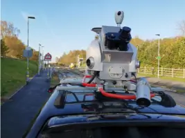
Our mobile mapping service captures high-density LiDAR and panoramic imagery for rapid, accurate spatial data collection. Using Leica Pegasus II technology, we deliver georeferenced datasets for asset inventory, route surveys, and digital twin modelling. This solution reduces field time and traffic management requirements while maintaining exceptional accuracy.
Structural Monitoring
We provide real-time and periodic structural monitoring using advanced sensors and Trimble 4D Control software. Our systems detect movement in buildings, bridges, and infrastructure with millimetre precision. Clients receive automated alerts and detailed reports for proactive maintenance and safety management.
Hydrographic Surveys
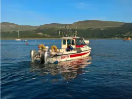
Our hydrographic surveys use multibeam sonar and ROVs to map underwater assets and environments. We deliver 3D models of ports, bridges, and reservoirs for condition assessment and asset management. Our MCA-coded vessels ensure safe operations in challenging marine conditions.
Utility Mapping
Using mobile GPR and PUMA-accredited methods, we locate and map underground utilities at highway speeds. Our surveys identify pipes, cables, and voids without excavation, reducing disruption and improving safety for infrastructure projects.
Geophysical Surveys
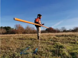
We employ ground-penetrating radar, seismic, and electromagnetic techniques for non-invasive subsurface investigation. Our geophysicists identify buried structures, geological features, and contamination risks to support construction, archaeology, and environmental projects.
Questions
What survey technologies does LandScope Engineering use?
We use LiDAR, ground-penetrating radar, multibeam sonar, and photogrammetry systems for comprehensive data collection across all environments.
Can you perform surveys in live traffic environments?
Yes, our mobile mapping and GPR systems operate at highway speeds without requiring lane closures or traffic management.
Do you provide data visualisation tools?
We offer U-GIS, our cloud-based platform for viewing, measuring, and analysing above and below ground survey data in 3D.
Are your surveyors certified?
Our team includes MRICS and MCInstCES members with specialist training in marine operations, geophysics, and structural monitoring.
How do you ensure survey accuracy?
We use GNSS, IMU, and control networks to achieve millimetre-level precision, exceeding industry standards like PAS128:2022.
Can you work on marine projects?
Yes, we have MCA-coded vessels and RYA-certified crews for coastal, port, and inland waterway surveys using sonar and ROV technology.