Established in 2011 by Michael Brett, CADMAP Limited is a UK-based surveying and geomatics company providing specialist services to a diverse client base. We deliver topographical land surveys, measured building surveys, PAS 128 utility mapping, CCTV drainage surveys, laser scanning and BIM modelling for clients across multiple sectors.
Our portfolio includes work for organisations such as BBC television productions, Mace, Arcadis, Barratt Homes, Cala Homes, Bellway Homes and Kier Group, alongside international private clients including royal family developments and overseas projects. We have completed assignments throughout the United Kingdom and internationally, including France, Ireland and the Falkland Islands, maintaining consistent standards of accuracy and professionalism.
Our portfolio includes work for organisations such as BBC television productions, Mace, Arcadis, Barratt Homes, Cala Homes, Bellway Homes and Kier Group, alongside international private clients including royal family developments and overseas projects. We have completed assignments throughout the United Kingdom and internationally, including France, Ireland and the Falkland Islands, maintaining consistent standards of accuracy and professionalism.
Served areas
- The whole UK - London, Surrey, Sussex, South East
Details
- Year established: 2011
- Employees: 25
- Licensed
- Insured
Highlights and features
- Topographical Surveys
- GPR Surveys
- Measured Building Surveys
- BIM Scanning
- Rebar Scanning
- Concrete Scanning for depth and Rebar
- 3D Scanning
- Revit Models
- Drainage Surveys
- CCTV Drainage Surveys and Jetting
Associations and certifications
- Full Member the TSA - The Survey Association
- CICES
Payment methods
- Bank transfers
Services
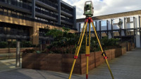 We provide detailed topographical surveys for architects, developers, landscape designers, and homeowners undertaking projects of varying scale. Our surveys accurately record land levels and ground features to support effective planning and future development. We deliver precise site data using advanced Leica total stations operated by fully trained surveyors. Our team also holds the necessary certifications required for access to construction and educational sites.
 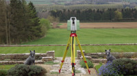 We provide professional measured building surveys carried out in accordance with RICS standards. Our team produces detailed CAD drawings including floor plans, elevations, and sections. We collaborate with architects and developers to support planning applications for property extensions. Digital outputs are supplied in DWG, DXF, and PDF formats. Our service ensures precise and reliable building information for a range of property types.
 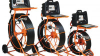 Our surveys make use of advanced sonde technology integrated within CCTV camera systems. This allows precise detection of pipe direction and location when used with RD8200 Cat and Jenny TX10 equipment. The system supports line and level assessment where required for drainage investigations. Results are combined with detailed inspections to establish comprehensive condition reports.
 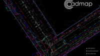 Cadmap Limited undertakes PAS128 GPRS surveys for clients ranging from homeowners to blue chip. A GPR survey is a non-invasive technique for locating and mapping underground features. Radar pulses are directed into the ground and reflected by electrical variations. Data is processed into images or 3D models used across construction, utilities, archaeology and drainage sectors.
  We at Cadmap Ltd carry out boundary surveys for a wide range of clients. This work requires substantial experience alongside appropriate surveying equipment, as simple tape measures and Disto devices do not provide sufficient accuracy. Our surveys are used for boundary disputes, land registry submissions, and precise area calculations. We regularly deliver reliable plans and documentation for client records.
 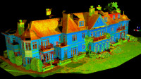 We deliver BIM and 3D laser scanning services tailored to a wide range of surveying projects. The Leica P20 enables rapid capture of high-density point cloud data, supporting efficient site workflows. It is particularly effective where time constraints or detailed information requirements exist. We support elevations, floor plans and specialist projects.
 Videos

Cadmap Ltd - Amazing Animation 3D BIM Services - Point Cloud to Model.
Scan to BIM | Point Cloud to Revit Model (LOD 400) | CADMAP Ltd London & South East
Experience the power of Scan to BIM with CADMAP Limited specialists in converting laser scan point clouds into highly accurate Revit models for architects, developers, and contractors. Whether youre working on refurbishments, listed buildings, or new builds, our LOD 100 to LOD 400 Revit models are tailored to your project needs.
Using the latest Leica RTC360 laser scanner, we capture detailed 3D data and produce fully coordinated Autodesk Revit models, ready for clash detection, planning, and construction.
Point Cloud to Revit Conversion
LOD 400 BIM Models for Architecture & MEP
IFC, RVT, DWG & COBie File Outputs
Ideal for Planning, Refurbishment, & Heritage Sites
Serving London, Surrey, Sussex & South East UK