
Business Details
Trusted Chartered Surveyors in Leicester
Established by a seasoned Chartered Surveyor with over 20 years of industry experience, Everything is Somewhere delivers precision-driven solutions rooted in integrity, reliability, and professionalism. Our expertise spans planning consultancy, aerial imagery, and GIS mapping, supporting clients in securing planning permissions, capturing high-resolution drone data, and leveraging spatial analytics for informed decision-making. As a Fellow of the Royal Institution of Chartered Surveyors (RICS), we adhere to rigorous professional standards, ensuring every project benefits from technical excellence and client-focused collaboration.Our services integrate cutting-edge technology, including UAVs and GIS software, to provide actionable insights for property management, development, and business intelligence. With CAA permission for commercial drone operations and 5m third-party liability insurance, we combine innovation with compliance to deliver trusted outcomes across diverse sectors.

Services
Planning Consultancy
Aerial Imagery
GIS Mapping
Drone Surveys
Property Management
Volumetric Analysis
Digital Surface Models
3D Modelling
Site Inspections
Data Visualisation
Highlights and features
- We offer 20+ years of chartered surveying expertise in planning and spatial data.
- Our team holds RICS accreditation, ensuring adherence to professional standards.
- We utilise CAA-approved drone technology for accurate aerial surveys.
- We provide 5m third-party liability insurance for client security.
- Our work integrates GIS software for actionable business and property insights.
Associations and certifications
- Royal Institution of Chartered Surveyors (RICS)
Services
Planning Consultancy
We guide clients through the planning process, from initial applications to securing permissions. Our expertise includes preparing technical reports, coordinating stakeholder engagement, and delivering project management to ensure compliance and successful outcomes for residential, commercial, and infrastructure projects.
Aerial Imagery
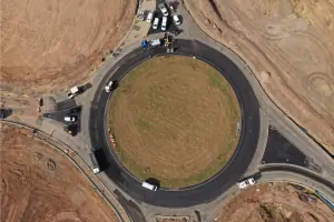
Using UAV technology, we capture high-resolution aerial stills and video for site monitoring, marketing, and inspections. Our services include orthomosaic mapping, 3D modelling, and volumetric analysis to support construction, agriculture, and environmental projects with accurate visual data.
GIS Mapping
We transform raw data into actionable insights through GIS mapping. This includes creating layered property plans, analysing sales distributions, and visualising trends over time. Our solutions help businesses and property managers make informed decisions using geospatial intelligence.
Drone Surveys
Our drone surveys deliver rapid, cost-effective data collection for construction updates, building inspections, and land management. Equipped with advanced sensors, we generate digital surface models, contour maps, and point clouds to support engineering, environmental, and development projects with precision.
Property Management
We provide detailed topographical surveys and asset mapping for property portfolios. By integrating infrastructure data into GIS platforms, we enable efficient management of drainage, utilities, and development options, ensuring accurate, up-to-date information for strategic decision-making.
People
Jeremy Murfitt
Chartered Surveyor
With over 20 years as a Fellow of RICS, Jeremy specialises in planning, drone surveys, and GIS mapping. He leads projects from concept to completion, combining technical expertise with client-focused solutions to deliver value-driven outcomes across property and infrastructure sectors.
Questions
What services does Everything is Somewhere offer?
We specialise in planning consultancy, aerial drone imagery, GIS mapping, and spatial data analysis for property and business applications.
Are your drone operations legally compliant?
Yes, we hold CAA permission for commercial drone operations and maintain £5m third-party liability insurance.
How does GIS mapping benefit businesses?
GIS mapping visualises tabular data spatially, enabling better analysis of customer locations, sales patterns, and operational efficiency.
Can you assist with planning permission applications?
Yes, we provide end-to-end support for planning applications, including technical reports and stakeholder coordination.
What industries do you work with?
We serve property developers, construction firms, environmental agencies, and businesses requiring spatial data insights.