Business Details
8 Years
experience
Your Trusted Partner for Marine Survey Solutions
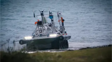
Ultrabeam Hydrographic was established in 2018 by industry veterans Gabriel Walton and Andy McLeay, combining over 55 years of collective expertise in coastal and offshore survey operations. We specialise in delivering high-precision hydrographic and geophysical survey services to ports, utilities, offshore renewables, oil and gas, and public sector clients. Our innovative approach utilises in-house designed uncrewed surface vessels (USVs) to enhance safety, efficiency, and data accuracy in challenging environments. Unlike competitors offering hydrography as a secondary service, we maintain a singular focus on marine asset inspection, supported by advanced 3D visualisation and data processing technologies. Our team's extensive experience spans shallow to deep-water projects globally, ensuring deliverables consistently exceed industry standards.We prioritise continuous research and development, integrating best-in-class technologies to address evolving client needs. Our commitment to quality control guarantees precision at every stage, from data acquisition to final reporting. With successful projects across the UK, Europe, the Middle East, Africa, and Asia, we deploy tailored solutions to meet complex marine infrastructure challenges. Our client-centric methodology aligns deliverables with technical objectives and stakeholder expectations, offering both standard and custom reporting formats. This dedication to excellence has earned us recognition as a multi-award-winning leader in sonar imaging and marine inspection.
Services
High Resolution Marine Survey
Hydrographic Survey
UXO Detection
Pipeline Inspection
Port Surveys
Data Processing
Details
- Year established: 2018
Highlights and features
- We offer 55+ combined years of specialist marine survey expertise
- Our in-house USVs revolutionise safety and data precision
- We operate globally across five continents with proven success
- High-definition sonar delivers sub-centimetre underwater accuracy
- Dedicated 3D visualisation transforms raw data into actionable insights
Services
High Resolution Marine Survey
Our high-definition sonar technology creates precise 3D models of underwater structures. Using state-of-the-art multibeam and laser systems, we deliver sub-centimetre accuracy for offshore wind farms, bridge foundations, and submerged infrastructure. This enables informed maintenance decisions and regulatory compliance for critical marine assets.
Hydrographic Survey
Specialist geophysical assessments combine multibeam echo sounders and sub-bottom profilers for comprehensive seabed analysis. We map underwater topography and shallow geology to support dredging operations, cable route planning, and environmental monitoring. Our data meets international hydrographic standards for port authorities and offshore developers.
UXO Detection
Integrated magnetometer and sub-bottom profiling systems identify unexploded ordnance on seabeds. Our methodology follows COTS 2019 guidelines, providing risk assessments and target classification for offshore construction projects. This service ensures safe site preparation for wind farms and pipeline corridors.
Pipeline Inspection
We conduct route clearance surveys and integrity assessments for subsea pipelines using side-scan sonar and ROV inspections. Our services cover pre-lay bathymetry, post-installation as-laid surveys, and long-term monitoring programs. Clients receive detailed reports on pipeline exposure and seabed stability.
Data Processing
Advanced software transforms raw survey data into interactive 3D models and GIS-compatible deliverables. Our workflow includes noise filtering, georeferencing, and volumetric analysis. Clients receive customised reports with cross-sectional views, contour maps, and actionable recommendations for engineering teams.
People
Gabriel Walton
Technical Director
Co-founder with 25+ years' experience in offshore survey operations. Specialises in USV development and deep-water multibeam systems. Leads technical innovation and project execution.
Andrew McLeay
Managing Director
Co-founder and industry veteran with 30+ years in coastal hydrography. Oversees business strategy and client relations. Instrumental in establishing USV-led survey methodologies.
Simon Baldwin
Project Manager
15-year veteran managing complex geophysical surveys for offshore renewables. Coordinates multi-disciplinary teams and ensures adherence to project specifications and deadlines.
Questions
What marine survey technologies do you use?
We employ in-house USVs, multibeam sonar, magnetometers, and sub-bottom profilers for comprehensive underwater assessments.
Which industries do you serve?
Our clients include offshore renewables, port authorities, oil & gas operators, utilities, and government agencies.
How do your USVs improve survey safety?
Uncrewed vessels eliminate diver risk in hazardous environments while maintaining data quality through autonomous precision.
Can you handle international projects?
Yes, we've completed surveys across five continents with mobile equipment and experienced deployment teams.
What data formats do you provide?
Deliverables include 3D models, GIS layers, cross-sectional profiles, and custom reports aligned with client requirements.
Videos